Things to do in Antequera and the Alpujarras
Things to do in Antequera and the Alpujarras
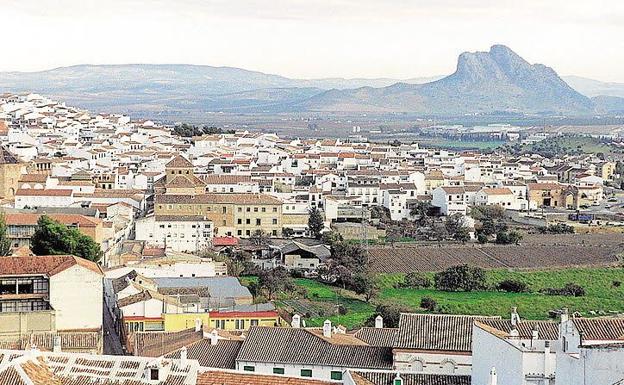
Just 47km north of Malaga, on the A45, Antequera sits at the foot of the El Torcal and El Arco Calizo Chimenea mountain ranges.
Situated over 570 metres above sea level, Antequera retains much of its Andalusian charm. The Moorish occupation of Antequera is still apparent with ruins of the castle and walls still visible. Occupying a commanding position, Antequera boasted strong natural defences in times of conflict and still stands proud as one of the largest municipalities in Malaga.
Properties for sale in Antequera are highly sought after by ex-pats and locals who want to make the most of the countryside while still being within easy reach of the coast.
As with many locations in Malaga, Antequera has become popular with ex-pats and foreign visitors but it has not been spoiled by mass tourism. Local bars, restaurants and cafés still offer wonderful local food at a fraction of the price you would pay on the coast. Try the speciality Antequeran molletes for breakfast, flat bread which is delicious split and toasted with olive oil and tomato. Local recipes and ingredients are served throughout the day for lunch and dinner and fresh local produce including fruits and vegetables are widely used. Just 60 minutes from Marbella, Antequera continues to attract day trippers from all over the Costa del Sol.
Antequera properties for sale attract holidaymakers and ex-pats who want to experience the ‘real Spain’ just an hour’s drive from the coast.
No visit to Antequera is complete without taking time to explore Fuente de la Piedra, just up the road from the town. This salt water lagoon attracts hundreds of greater flamingoes which nest here. There are plenty of viewing platforms and parking areas around Fuente de la Piedra and the flamingo lake is well signposted from the town. The limestone rock formation of El Torcal is also a must-see spectacle and this amazing nature reserve attracts visitors from all over Europe.
The region´s economy relied heavily on agriculture and furniture manufacturing. Tourism has overtaken agriculture as the main industry in Antequera and the city´s museums are home to 80% of all the art treasures in Malaga. The most spectacular monument is the Real Colegiata de Santa Maria la Mayor, a national monument overlooking the whole town. With diverse architectural influences from the days of Roman and Moorish rule, Antequera offers a wealth of culture, history and fine art, plus some damn fine restaurants.A mountainous region of the Costa del Sol, La Alpujarra is situated in the provinces of Granada and Almeria (eastern part in Almeria and the western part in Granada). This is the region of fairytales and beautiful countryside. Consisting mainly of valleys with the Sierra Nevada to the north and the Sierras Almijara separating it from the coast, La Alpujarra offers stunning scenery and Andalusian charm.
Reliable irrigation from the Sierra´s rivers ensure rich, fertile soil in the Granada region and you will see an abundance of lemon, orange, grape, persimmons, almonds and fig trees. Though much drier, the eastern part of La Alpujarra still boasts some amazing scenery. The largest and most spectacular villages in the area include Lanjarón, famous for its spring water, Orgiva, Ugijar, Laujar and Trevélez, which is the highest recognised town in the whole of Spain.
Properties for sale in Antequera
Properties for sale in Antequera include village houses, fincas, apartments, villas and townhouses.
Here are the 5 routes of the Axarquia. Andalucia's hidden secret! Ruta de la Pasa, Ruta del Sol y del Aguacate, Ruta del Sol y del Vino, Ruta Mudéjar and Ruta del Aceite y de los Montes...
Ruta de la Pasa
Ruta de la Pasa or "the route of the raisin" is steeped in history. You can almost hear the cry:
STAND AND DELIVER!
As one of the most feared outlaws, El Bizco gallops towards you on his snorting black Andalusian stallion, foaming at the mouth and stamping its mighty hoofs! El Bizco, now long dead, has a museum in his honour in the village of El Borge. Located in the house where he was born on September 2nd, long ago in the nineteenth century. Luckily for us, it is one of the places you can stop for refreshments or even the night, on your journey following the RUTA DE LA PASA.
We start the route of the raisin safely back in the 21st century at Moclinejo some 450 metres above sea level, 20 km from Málaga and 32 km from VélezMálaga. If you drive into the village itself there are plenty of places to sample the delicious local wine, but be warned it´s stronger than you think!
First of all, to get to the village:
- Turn off the autovia el Mediterráneo at km 257 for Torre de Benagalbón and drive up past the village to Moclinejo which should take about 10 minutes.
- Just before the village is the VistalMar Hotel where you should stop for refreshment and take in the magnificent views from the terrace.3. Once there a good snack is a handful of raisins as you walk its steep streets!
- On the first Saturday of September this village throbs with tourists who come to sample the cold garlic soup at the annual Festival of Ajo Blanco.
- We continue our route by turning left at the bridge up towards El Borge where apart from our bandits birth house, don´t miss the parish church of Our Lady of the Rosary on the Plaza Mirador, a Gothic-Renaissance structure of the sixteenth century.
- Driving onwards and upwards we are now only a few kilometres from our next stop The Fountain of Paradise, Cútar, known for its oil and raisins. This village remembers its Moorish origins every year at the Monfi Festival where history, culture and traditions unfold in the streets with displays of falconry, music, tea ceremonies and belly dancing. The Moorish rebels called Monfi, resisted being evicted from a land they had inhabited for eight centuries.
- Our next port of call is the famous mountain top village of Comares. In summer when the river bed is dry you can drive from Cútar down to the river and come off again at the Salto del Negro bridge, turn left and then right up the 7 klm road to Comares. For the less adventurous the route continues down into Benamargosa, turn left after the bridge and continue until you see the left turn up to Comares. The first watering hole on the way up to the village is the Mayors Bar, Atalaya where you can sample delightful local cuisine while taking in magnificent vistas down to the coast at Torre del Mar. Further up in the main square do stop to take photos of the view and see if you can spot the villages of Cútar, Iznate , Benamocarra , Vélez-Málaga, Torre del Mar, Benamargosa, Canillas de Aceituno and Alcaucin. Whilst up there make sure to stroll into the beautiful courtyard of the Molino de los Abuelos Hotel for a well deserved cool drink before descending back towards Málaga and the last village of the route Totalán.
- To get to Totalán you need to turn left just before Olías. Totalán is a place whose gastronomy is closely linked to the Mediterranean diet with Gazpachuelo, a stew of chickpeas, Gazpacho and the famous Chanfaina stew with peppers, sausage, black pudding, pork and offal. Stomach full it´s time to head back to the coast but don´t forget the shopping centre at the entrance back onto the autovia Centro Commercial Rincon de la Victoria, where if you are not already too exhausted you can shop ´til you drop!
Ruta del Sol y del Aguacate
Our next route, the La Ruta del Sol y del Aguacate takes us on a 75 km trip through beautiful countryside and six municipalities, Rincon de la Victoria, Macharaviaya, Vélez-Málaga, Benamargosa, Benamocarra and Iznate.
- We start our tour in the seaside resort of Rincon de la Victoria, just 12 km from Málaga and 21 km from Vélez-Málaga, at the far south westerly point of the Axarquia. Here we find tropical vegetation and large expanses of sugar cane. Mangos, Papayas, Custard Apples and of course Avocados thrive in this area due to the exceptional microclimate which is created by the mountains of Almirara, Alhama and the Natural Park of Tejeda.
- A good place to visit before the tour starts is the Cueva del Tesoro in Rincón de Victoria which is the only marine grotto in Europe.
- Back into daylight and with the sun once again proving this area has the best climate in Europe, we take the N-340 coastal road for 3 km before turning left onto a 9 km climb to Macharaviaya. Founded in the sixteenth century on a former Moorish settlement, this charming village with its cobbled streets hasenchanted visitors who love romance as well as artists and artisans who have made it their home.
- The mid-nineteenth century modernist poet and writer Salvador Rueda was born close by in Benaque and the noble Galvéz family lived there in the 18th century, it was the birthplace of José de Gálvez who became Marquis of Sonora and Minister for the Indies, his ashes can still be found in an urn in the parish church. On the way back down to the coast do be sure to stop at the little coffee shop opposite the golf driving range, they do a great cappuccino!
- To continue we go back onto the N-340 heading east until we come to the coastal resort of Torre del Mar from where it is just a short drive or tram ride to our next stop the capital of the Axarquía, Vélez-Málaga.
- This busy, bustling town is steeped in history and needs a page of its own to tell of its many attractions, in fact the old town was declared a historic artistic monument in November 1970 and a must see are the beautiful paintings of local artist Evaristo Guerra in the Hermitage de los Remedios, patron of Vélez. A real work of love.
- We move out of the centre of Vélez and take the C-335 past Trapiche, turning left at Bar El Cruce, our next stop Benamargosa is signposted as being just 8 km.
- Opposite the turn for Axarquia airport a track leads up to the Buddhist Stupa which is also worth a visit. If you are driving a 4 x 4 or quad bike you can drop down from the mountain top after visiting the Stupa right into the centre of the village of Benamargosa but the normal road is interesting enough with its evergreen plantations of avocados, mangos and citrus fruits, strikingly verdant this veritable oasis strongly contrasts with the surrounding dry hills.
- As you drive into the village, just before the bridge on the right hand side is the 16th century parish church of La Encarnación.
- Opposite the church is a bar which makes fresh churros (long thin strands of donuts) on its front terrace which are very tasty with hot chocolate (or sugar) and not at all fattening!
- The route then retraces itself back to the C-335 in the direction of Vélez-Málage until a right hand turn takes you the 4 km to Benamocarra. To make this more interesting you can just drive onto the dry river bed at Benamargosa and take it all the way to Benamocarra, infact you can follow it all the way to our final stop Iznate!
- In the summer the dry river beds are used as roads and even a normal car can take this river bed route to Benamocarra and Iznate.
- Benamocarra boasts a 16th century parish church of Santa Ana and a new fountain in the main square where all the village men stand and while away the hours.
- To finish our tour we continue along the 5 km winding road to Iznate. A steep village with stunning views of the mountain ranges, breathtaking at any time of day, but do keep a look out for the magic hours. Where cast shadows creep into every crevice, stimulating the eye with super 3D effects. When is magic hour I hear you ask? Just after sunrise and just before sunset.
- Iznate's 16th century church of San Gregorio was rebuilt after the Moorish rebellion and restored 50 years ago.
- At the entrance to the village are lovely gardens with new gym equipment put there to entice the villagers into keeping fit! Although most villagers keep fit by walking between the villages in the early morning or evening and you will often see them in small groups or pairs on the roads at these times.
- The village is famous for its Muscatel grapes and every year these are celebrated in August at the Fiesta de la Uva Moscatel which takes place on the first Saturday of the month. Locals firstly attend mass and then enjoy a flamenco festival with free local produce.
- The route finishes in Iznate and to return to the coast you just continue on the same road down past the small village of Cajiz and under the motorway, following signs to the beach.
Ruta del Sol y del Vino
The third route of the Axarquia La Ruta del Sol y del Vino takes us in search of Sun and Wine, a tourist attraction to be sure! The hills of the Axarquia are laden with vines defying gravity which produce both the Malaga raisins as well as the sweet wine the region has been famous for since Roman times. Be warned though, if you are offered a glass by a local farmer straight from a plastic bottle it is very potent! Strong and sweet, it tastes a bit like sherry. The 55 km Ruta del Sol y del Vino takes us through Algarrobo, Sayalonga, Cómpeta, Canillas de Albaida, Torrox, Nerja and Frigiliana. Algarrobo and Torrox are both coastal and inland with beaches prepared for tourists and villages retaining much of their Moorish inheritance.
- We start our tour by driving along the N-340 to Algarrobo Costa and then turning 4 km inland to the village itself. Here the streets (as in most villages) are narrow and winding, so it is best to park the car and walk. Be aware that if you arrive there at 2pm when all the inhabitants drive home to lunch you have to squeeze into doorways to let them pass with their wheels screeching on the hot tarmac!
- 5 km further up the road at an altitude of 355 metres Sayalonga boasts a unique circular cemetery and a pretty square you can see from the road with bars and restaurants tempting you to stop for refreshment. A good idea as it is a further 9 km to Cómpeta where the winding road takes you past an unusual structure reminiscent of Gaudi and on arriving in the village there is a Gaudi like lookout point decorated with glazed mosaic tiles.
- Whilst in Cómpeta a trip to the wine museum which is also a bar and restaurant is a must! As is the central Plaza Almijara next to the gold domed Church of Asunción where you can while away an hour or so in the shops, street cafe´s and tapas bars.
- The village is famous for its honey, pottery and vino de terreno. Every year on August 15th the town celebrates this sweet wine in La Noche del Vino where 1500 litres are consumed by merry townsfolk and tourists alike.
- Back on the road the route continues to the next village of Canillas de Albaida just 3km away on the slopes of the Sierra de Tejeda and Almijara mountains on the borders of Malaga and Granada. This is an area protected by the Andalusian government and if you are lucky you can spot eagles, wild boar and mountain goats amongst the pine and oak trees.
- In the main square you can find the 16th century parish church of Nuestra Señora de la Expectación and before you leave do visit the Arab stone bridge that joins the Cájules and Turvilla rivers.
- To continue our route we have to go back on the road to Cómpeta and then a further 15 km down to Torrox, the second village with both a village and coastal resort.
- If you want to stretch your legs after the drive down from Cómpeta then take the paseo de maritime from El Faro in a westerly direction and maybe even diveinto the waves to refresh yourself before drying off and following the N-340 east to Nerja.
- Just before finishing our tour in this picturesque sea side town we head inland for 6 km to sample the delights of Frigiliana, one of the prettiest of the whitewashed villages and as such the winner of many national and regional awards for conservation and beauty. Here you can find many tiny shops selling local handicrafts including linen, lace, fine basket ware and ceramics. The village has two distinct centres, one of medieval and Moorish origin and the other a recent construction in keeping with its historic architecture.
- Finally, the last stop on our route of Sun and Wine takes us back to the town of Nerja with its labyrinth of narrow cobbled streets, reminiscent of the Lanes in Brighton or The Shambles in York. Here you can shop ´til you drop but don´t forget to visit the Balcón de Europa, the famous Burriana Beach and the Nerja Caves which are actually situated in Maro the small village 3 km to the east of Nerja.
Ruta Mudéjar
The 4th Axarquia tour follows La Ruta Mudéjar. We drive 75 km through 5 municipalities in search of Muslim architecture which developed from 12th to 16th centuries. Not really a pure style it was constructed for Christians by the Moors and native Andalusians who did not convert to Christianity but nevertheless remained in the area. It was such an interesting look that many of the elements continue to be incorporated into Spanish architecture today.
The expression Mudejar Style was first used in 1859 by José Amador de los Ríos who was an archeologist and Andalusian historian. Typical Mudejar materials used in construction were poor but useful, allowing buildings to be constructed quickly, cheaply and most of all attractively, using bricks, glazed ceramic tiles and plaster. The architecture itself showed a strong Muslim influence with bell towers and wooden ceilings often ornately carved, as seen in many churches in the area.
- The starting point of this route is in the village of Arenas and to get there the easiest way is through Vélez-Málaga on the A117 which is 10 km of winding country road full of almonds, olives and vines. If you happen to drive there on 12th October the village will be celebrating its Mule Fair so you probably won´t get much further and may as well enjoy the free paella and festivities. The Mudejar influence in Arenas can be seen in the 16th century parish church of Santa Catalina.
- So now to Archez itself, situated on the Sayalonga river valley and the foothills of the Tejeda and Almijara. From its Arab past only one jewel remains, the minaret of the Iglesia de Nuestra Señora de la Encarnación, it stands 15 metres high and dates from the 15th century. It was declared a national historic artistic monument in 1979 by royal decree and is decorated with entwined diamond shapes with curved edges which are cut away above the brick.4. Lets pause before continuing along this historic route and soak up the atmosphere along with the sunshine on the terrace of Venta el Curro (closed on Thursdays) overlooking the river.
- So now to Archez itself, situated on the Sayalonga river valley and the foothills of the Tejeda and Almijara. From its Arab past only one jewel remains, the minaret of the Iglesia de Nuestra Señora de la Encarnación, it stands 15 metres high and dates from the 15th century. It was declared a national historic artistic monument in 1979 by royal decree and is decorated with entwined diamond shapes with curved edges which are cut away above the brick.4. Lets pause before continuing along this historic route and soak up the atmosphere along with the sunshine on the terrace of Venta el Curro (closed on Thursdays) overlooking the river.
- Driving inland and upwards to 579 metres our next stop is Salares, situated on the very edge of the Tejeda National Park and Game reserve. This white gem of a village is steeped in history and was inhabited by the Phoenicians, Greeks and Carthaginians. Once known as Salaria Bastitanorum by the Romans the urban design of this tiny village has changed little since Muslim times. You can stretch your limbs here by using the free outdoor gymnasium equipment before climbing up to the Parish Church of Santa Ana, built in Mudejar style on the site of an ancient mosque.
- Continuing our climb up towards Mount Maroma, at 689 metres above sea level we discover Sedella, so named, according to the town hall website, because Queen Isabella when told of the fight between Christians and Muslims at an area known as Arroyo de la Matanza, said Sé de ella (I know about it).
- After parking the car and walking up into the village one of the first places of interest is the public laundry or wash house situated between three green trimmed arches, which before the invention of washing machines was in constant use by the towns women.
- Onwards and upwards to the main square and the most unique building in town, the Casa del Torreón or Tower House, Mudejar in origin and the former home of the Mayor of Donceles, Lord of Sedella,. It was built in the 16th century in the Mudejar style over a quadrangular floor plan. The tower has twin arches on Renaissance columns with a beam supported hip roof, majestically sitting at the highest point in the village. Up a flight of 12 steps is the church of San Andrés with its square two part tower and octagonal belfry, the only vestige of the original 16th century building.
- Before our final stop on the Mudejar route, just 8 km further on from Sedella you may like to take a refreshing dip in a cool spring as you pass through the Ragihes Nature Reserve with its waterfall and picnic area before visiting Canillas de Aceituno. Be sure to take a sip of this pure water and discover its healing powers!
- At the top of the final village of our tour is the 16th century Gothic - Mudejar style church of Nuestra Señora del Rosario and the only remains of Arabic origin left in the centre of town are the tower known as the Reina Mora and a well next to the Huertezuelo fountain.
- Our tour over, the best way back is to continue on the same road until you pick up the C-355 to Vélez-Málaga but before winding your way down again, do stop to take in the magnificent views of the mountains, lake and distant coast, a real photo opportunity!
Ruta del Aceite y de los Montes
La Ruta del Aceite y de los Montes is the last of the 5 routes of the Axarquia and we travel once again back into bandit country, so be prepared! Our first route conjured images of El Bizco, galloping towards you on his snorting black Andalucian stallion, foaming at the mouth and stamping its mighty hoofs! This route travels to Alfarnate where the most terrifying bandit of all, El Tempranillo (the early one), threatened diners at the famous Venta de Alfarnate, that was built at the end of the 17th century. He made them eat their wooden spoons and watched on as they cracked their teeth!
The government set up the Guardia Civil in 1844 to try to stop bandit activities, some bandits even converted to become Guardia Civil themselves! When taking this 62.5 km route in summer you will notice it’s a shade warmer than some of the other routes, as this time we rise up deeper into the heart of the Axarquia. Through the mountain ranges that tower majestically above the reservoir at Viñuela, silent keepers of the areas tumultuous past, guardians of its history through Palaeolithic times to the Phoenicians, Carthaginians, Greeks and Romans, who all left their mark.
The villages we drive through have kept their rich and varied legacies of past civilisations. Their festivities, when not religious, are based on every day occurrences typical of their region, like cultivating the vine for raisins or wine or celebrating their Moorish past. This route is 62.5 km long and runs through the mountains in the north west of the Axarquia travelling through the municipalities of Viñuela, Alcaucin, Periana, Alfarnate, Alfarnatejo , Riogordo and Colmenar.
- We start our journey in Viñuela, 45 km from Malaga, where in mid September a two day festival celebrates the raisins that are dried on the hillsides, on huge beds that look like giants graves!
- The area is now most famous for its reservoir which was built in 1981 and although folklore has it that there is an entire village complete with church steeple at the bottom of the lake, this is not true. A young Spaniard told me his grandmother had a house situated at the bottom and they were sad when it was flooded but agreed the area is now very beautiful because of it.
- Non motorised water sports are some activities enjoyed there during the summer.
- From Viñuela we travel north on the C-355 and then turn right at Puente Don Manuel, drive over the bridge and turn left up to Alcaucin. This village has an annual fiesta on Halloween to celebrate the chestnut.
- Our third stop on this route is Periana, 13 km from Alcaucin. To get there you can either drive down through Venta Baja and pick up the Periana road C-340 or drive back the way you came turning left at Puente don Manuel back onto the C- 355 and then left onto the C-340.
- The views from Periana are hard to beat. From here you can see mountains, lake and the distant coast.
- The name of Periana dates from 1761 but the town was rebuilt after an earthquake in 1884.
- Verdial Olive Oil is made in the village and sold far and wide.
- La Día del Aceite Verdial in late March is a festival to publicise this oil, extracted from the local verdial olive and prepared in traditional mills to produce a totally natural, fruity flavour.
- Moving on there are sulphurous Moorish baths at Baños de Vilo 2 km north of the village and a museum of oil in Mondrón Periana, a good place to stop before the climb up to the most northerly village in the Axarquía, Alfarnate.
- The drive here is spectacular with the rugged mountains of Enmedio, Palomera and Jobo and the peaks of Chamizo, Gallo and Vilo towering above. By contrast the land is flat and cultivated with farms dotted about and horses grazing contentedly.
- The streets in Alfarnate are wide and flat in total contrast to most Pueblos Blancos and the river Palancar divides it in two with three picturesque bridges joining it together again, a definite photo opportunity. As is the 16th century church of Santa Ana with its Mudejar minaret.13. Time to change horses so to speak and stop for refreshment at the famous Venta de Alfarnate, mentioned earlier, with its museum and restaurant. If you visit the bar during winter, a welcoming log fire will warm you before you are taken through behind the bar, past a prison cell complete with wax work bandit, into the dining room where a delicious meal awaits you.
- We start our downward incline now to our final two villages. First Alfarnatejo, a small village with wide streets and 16th century church of Santo Cristo de Cabrilla, its square tower built in the Mudejar style of fired bricks. Bandits sheltered here in the many caves surrounding the area and it is easy when standing alone admiring the wonderful craggy mountain views to conjure them up again, but in a romantic way with an Antonio Banderas like character sweeping you off your feet and throwing you on the back of his horse. It’s also a natural place to sit and meditate and one can almost hear the eerie music of Picnic at Hanging Rock! Or see the sad Indian from Peña de los Enamorados drifting past in search of his lost love. A local legend about an impossible love affair between a young Christian man from Antequera and a beautiful Moorish girl from nearby Archidona, who were driven to the top of the cliff by the Moorish soldiers, where, rather than renounce their love, chose to hurl themselves into the abyss.
- Shrugging off these ghosts of the past we drive on to our final destination, but first a strong dark cafe solo at the bar on the right in Pulgarin to bring us back to our senses! The route continues with a return to the C-340 turning right and on to Riogordo, situated in a lush valley by the river Cueva. Here we can visit the Ethnographic Museum at Calle Iglesia where there are nine exhibition rooms open to the public, or the church itself the 16th century Virgen de Gracia.
- If you visit the village at the end of May you may be offered a local dish prepared from land snails cooked in stock and served with olives as the villagers celebrate Day of the Snail.
Back